The Whites

The White Mountains of New Hampshire are both gorgeous and brutal. There’s something about the majestic ruggedness that beckons to hikers from all over the country, who populate the rocky trails among pitching peaks of glacial landscape in the fabled wilderness of northern New England. Most are here just for the story to tell their friends at work far from the city, while others are seeking a more transcendent experience, in search of that elusive perspective that lends clarity to their outlook, that uncanny sensation of abandoning everything they had created to lose themselves in a stark wilderness that predates civilization.

Most hikers go to Mt. Washington. The harsh atmosphere and panoramic views provide a cross between Scotland and the Alps, with winters so deep that the Tuckerman Ravine trail is closed nearly until summer because of small avalanches caused by snow-melt (or snow itself). I met a hiker with a pair of skis who claimed he was going to try to ski there—in early June. Mount Washington is where people want to hike and where a shocking number of people have died, vanishing into crevasses or one of the hundreds of avalanches in winter, or even succumbing to the wind and fog that comes year round. All of the Whites are deadly, but Mt. Washington is actually one of the deadliest mountains in the country because of how many people visit, and because of how cold and windy it can get. For decades the record wind speed for the entire planet was recorded by the Mount Washington Observatory, which still holds the record for strongest land wind speed ever recorded (231 MPH). In the winter the temperatures can plummet so low that, combined with the wind chill from world-renowned gusts, conditions rival those of Antarctica and the Himalayas.

The Presidential Range, where the Mount Washington Observatory is located, does not look that dangerous at first glance, which is one of the reasons so many people underestimate it. After all, the altitude is only about 6,289 feet. But meteorologists say there is something unusual about this place, where the conditions mimic that of a mountain at least three times its altitude. Last winter they experienced record colds, with a windchill hundreds of degrees below zero. Scientists at the observatory illustrated this point by stepping outside (in a space suit) and dumping a boiling pot of water into the air. It vaporized into ice crystals and blew away instantly.

I’ve climbed Mt. Washington eleven times now over the course of three years and each time was a little different. The last time I was up there, in early June, snow mixed with the rain and fog and made navigating the massive swath of boulders rocks that comprises the path nearly impossible. But on sunny days it is heavenly, and in the fall the entire range turns golden yellow and you can ride the quaint cog railway straight up the western side of the mountain (called a ‘cog’ railway because it climbs the incredibly steep slopes for miles by way of a cog and gear mechanism in the bottom of the train). On those days, it is hard to tear myself away from the serene beauty.

But when it is raining it is hard to find your way. When I got to the top in my most recent visit I entered the observatory building to find it was almost deserted. Because of the bizarre wind, the cog railway, and the perilous auto road on the east side of the mountain that allows visitors who don’t mind replacing the transmission of their cars, the summit is a popular tourist destination, but today it was weirdly empty and the few national forest wardens were about to close down. A nervous family from Colorado was talking with one of the national forest wardens in the observatory. Colorado is dry and many of the mountains are mild in comparison, which led this family to try the hike with no waterproof clothing and not enough warm layers. Up here, the weather is leaden and damp, and the trail is nearly impossible to follow in inclement conditions, which is why the national forest service builds large cairns along the footpath.

Across several valleys and ridges is a lesser-known mountain that I have visited just as often. Mt. Lafayette. This is where I came to understand the White Mountains. The stark peak is at the end of Franconia Ridge, near interstate 93 in the heart of New Hampshire. One of the tallest and narrowest ridges of alpine tundra in the heart of the White Mountains, it is extremely difficult to climb. Hikers everywhere will be agonizing up the root and granite trails, hunched over, sweat dripping, calves seizing as they put one foot in front of the other. Some of the trails are nothing more than stone stairways so steep that after only a few dozen steps experienced hikers have to sit down and let their pounding hearts catch up to their stumbling feet.
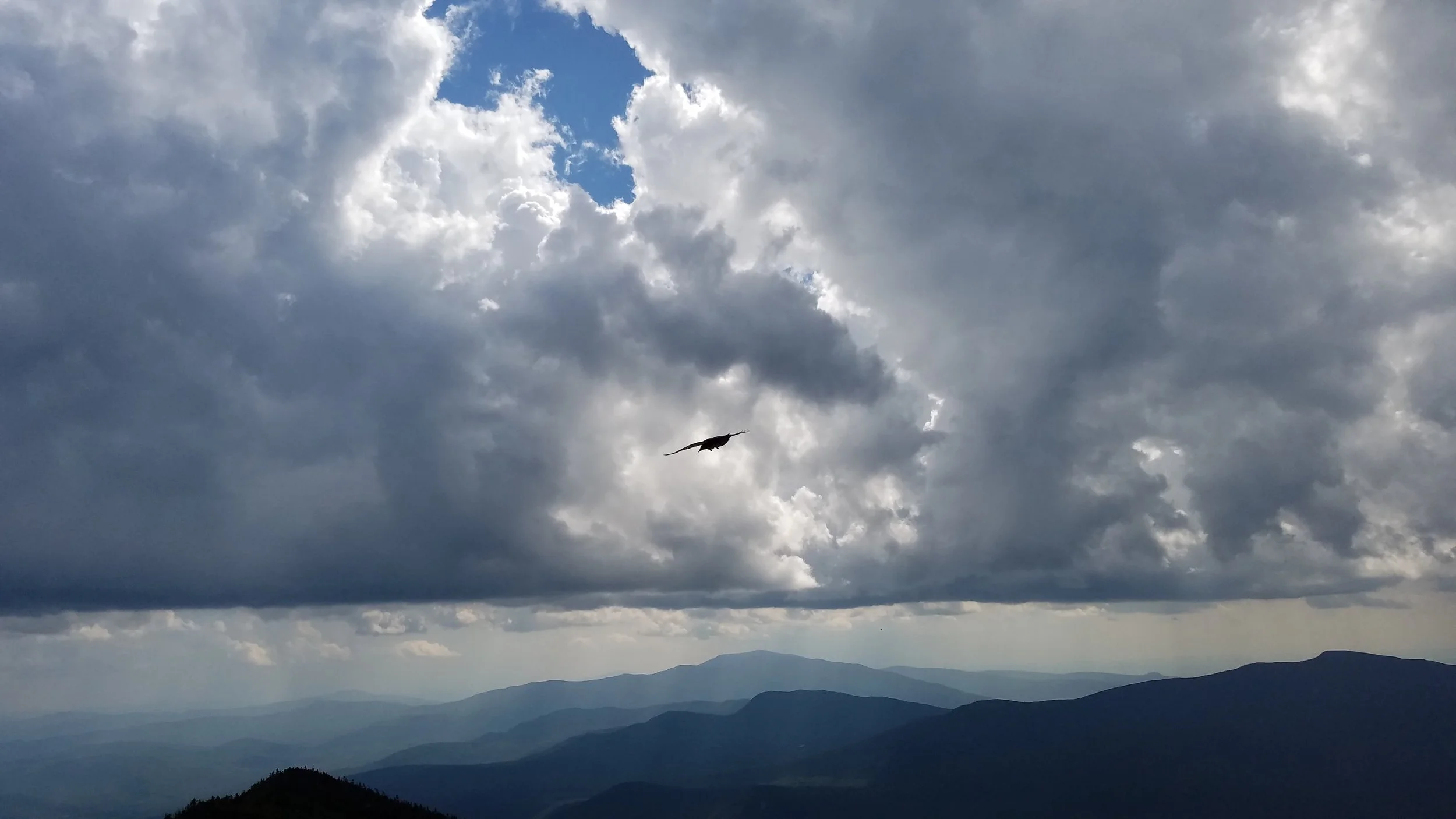
But once on top all thoughts of the ascent are lost in the crunch of rubble underfoot, the whispering of the breeze through the lonely boulders, the smell of distant evergreens. The ridge is so narrow at places you can stand and look down into rugged slopes on both sides and gaze across the U-shaped valleys at the Presidential Range in the far distance where Mt. Washington lies. As long as I can I always linger in the clouds that are perpetually dusting the summit, where I sit on a boulder to stare at Cannon Mountain across the incredibly narrow Franconia Notch. Nearby is an old foundation of blockish stones, perhaps the now-abandoned sight of an old observatory. Now the AMC maintains a shelter that hikers can rent, though it is well below the tree line.
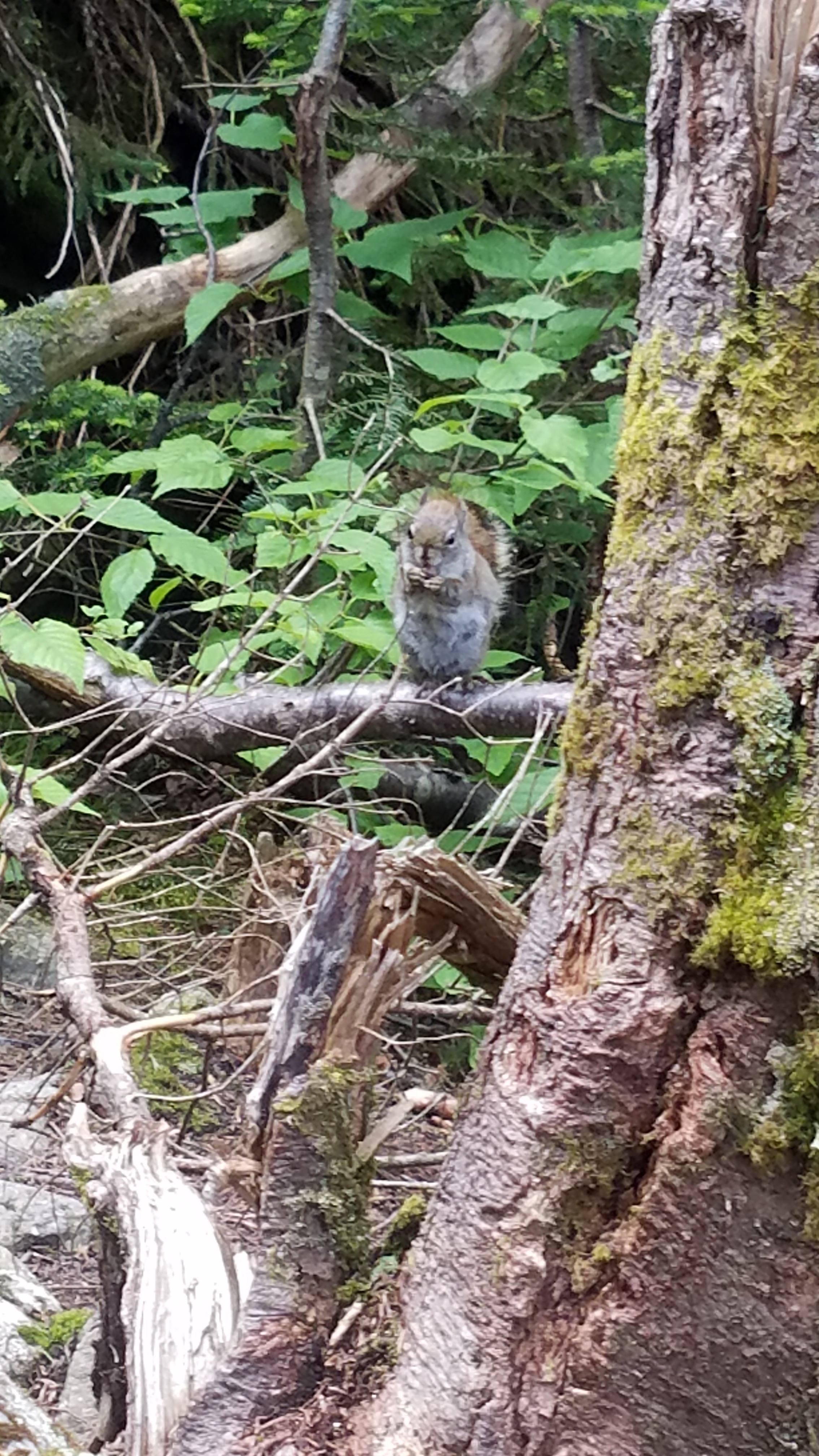
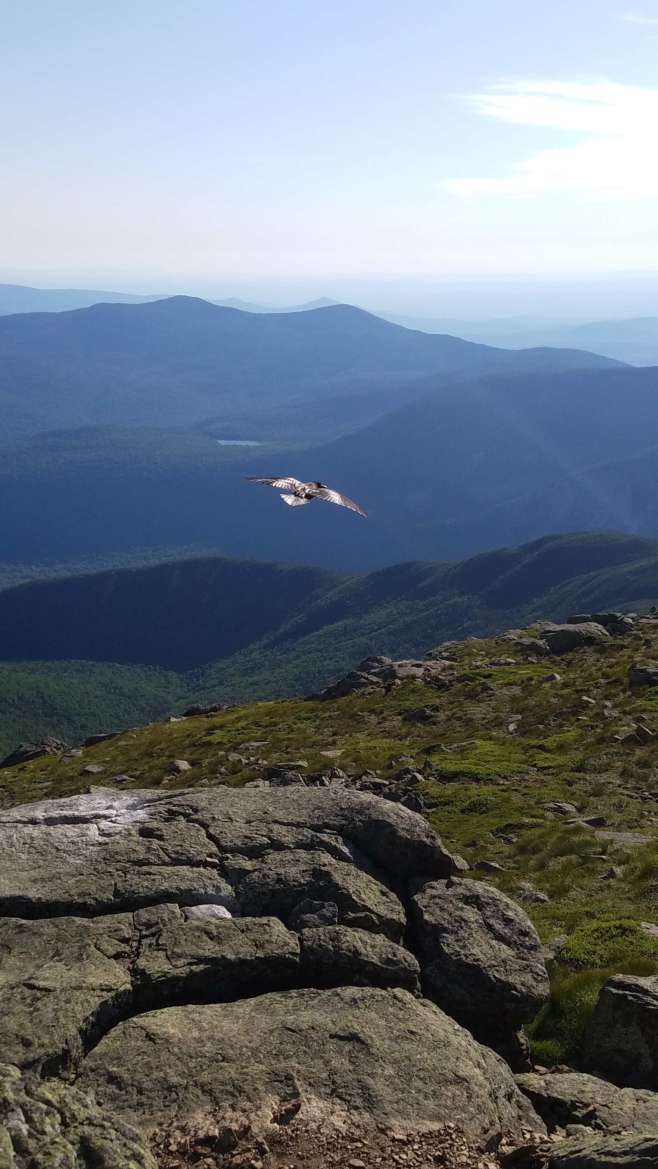
Even the animals are different here. Moose and black bears roam the trails and sometimes swim in the river. Though I’ve seen my share of black bears in trees and along trails, I am far more interested in the smaller animals, as the furry creatures seem to have the most personality in New England. I once saw a mother porcupine playing peek-a-boo with her baby around a tree (I kid you not). Chipmunks will jog along on the sides of the trail with me, squeaking and watching me before diving into the rocks. Ravens have walked right up behind me to snag food in what I can only describe as a playful and friendly manner. My favorite encounter was on Mt. Lafayette itself. While eating a granola bar as I descended I noticed a red squirrel watching me from his perch atop an old pine. When I passed he started cackling and purring angrily, then raced ahead of me and climbed another tree, within my line of vision, and started chattering again. I stopped, stared at him, and thought surely he couldn’t be begging food. But when I knelt down and held my granola bar out toward him he crawled down from his perch and hopped toward me. He nibbled at the granola while it was still in my hand and then put his paws in the sides and forced the bar into his mouth. Finally, with the greatest impudence, the little rascal pulled my entire granola bar out of my hands and made off with it.

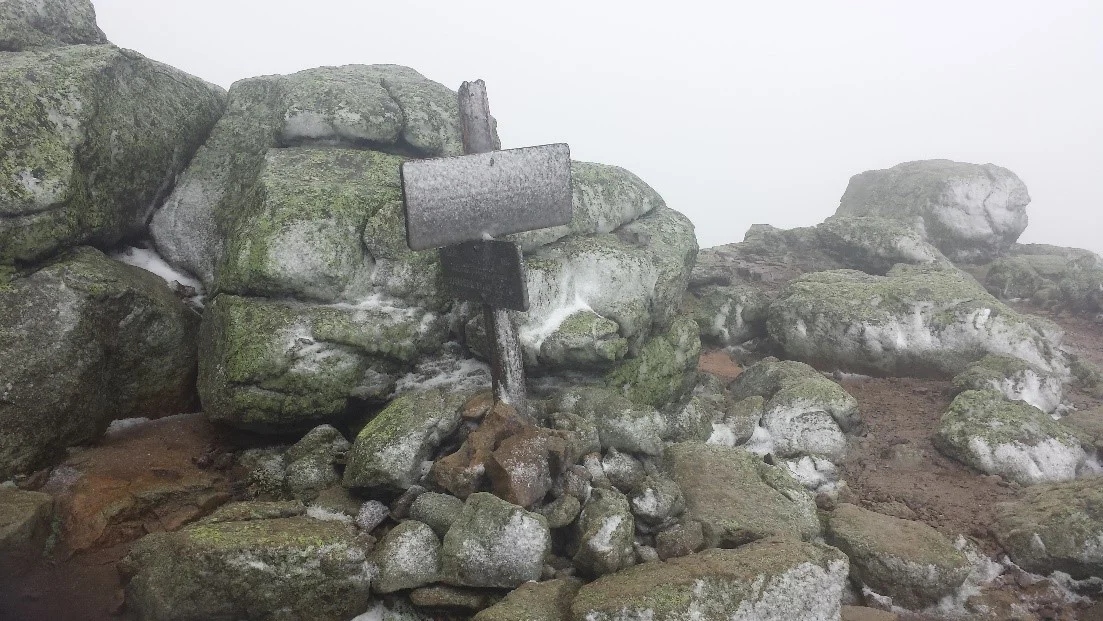
As I said, the White Mountains can be deadly, and I have gotten first-hand glimpses of this on multiple occasions. The third time I climbed Mt. Lafayette I saw the temperamental side of the White Mountains. It was June and the weather was inconspicuous as far as I was concerned, a mild 68 degrees at the base, overcast but windy. As I climbed, the ceiling of a cloud sank closer to me, and every hiker I passed warned me of the conditions on the ridge. Rain turned to sleet, and then, with nearly 1500 feet still to climb, flurries mixed with the rain. When I got to the treeline a blizzard began hitting Franconia Ridge and the alpine tundra, even the summit signs, were covered in ice. As I started walking the ridge I made one last snapchat: “This is bad,” I said, and then said again: “This is really bad.” The second half of my message was inaudible in the wind, which was gusting over 60 miles per hour. That was the last anyone heard of me because my phone died right afterward, even though it had over 50% remaining. I only managed to snap a few pictures, and these were at the first summit, Haystack, which is far lower than Lafayette. The extreme conditions have been known to cause phones and even rescue beacons to malfunction inexplicably, the mountain playing tricks on hikers.
Alone on top of the world, I couldn’t feel my hands or half of my face, my bare legs looked like they were covered in white fur because of the snow, sleet cut my eyes when I looked west, I couldn’t breathe through my left nostril, but I was happily ambling the trail between bouts of jogging. There is something about the rugged isolation of those mountains, the harshness that keeps the faint of heart from exploring their heights, that draws me back again and again. That day I jogged through a frozen tempest on a narrow ridge over a mile high, dizzying slopes on either side that plunged into angry clouds. Conditions can unravel fast in the Whites because the wind and precipitation can lower hikers’ body temperatures at a dangerous rate. As I scrambled over boulders slick with wintry frosting I had to slow to a walk, and I felt my core temperature sinking. Several times I hunched behind a rock to regather my strength and eat the last of my food.

How bad exactly was it for me? I regularly experience the early stages of hypothermia in the White Mountains, though I am very careful to prepare suitably because I move fast, often jogging on the mountain tops, which means I have to travel light and can usually handle the cold. But that day it took me four hours to warm up when I got back to the parking lot and my hands didn’t work right until the following afternoon. Perhaps the best way to illustrate how bad conditions were is to tell it from a different perspective. A year after I got caught in that storm I was browsing the internet for stories about Mt. Lafayette and came upon an article in a Boston newspaper about a couple who had gotten caught on Franconia Ridge during a similar storm. They had lost the trail in the chaos near Mt. Lafayette and had to huddle together in a stony nook to keep warm. They sent an emergency message and rescuers, who routinely go to the aid of such hikers, arrived as soon as they could with warm liquids and dry blankets to help the pair down the mountain. The rescuers said that the hikers would have been dead within hours in those conditions. Then I saw the day that the hikers had been rescued: it was the Saturday of the first weekend of last June, the exact day I was up there. They had gotten caught in the same storm and nearly died. For all I know I might have passed right by them in the cloudy chaos without realizing it.

Don’t let this discourage you from visiting the Whites. Late July and early August is a reliable time to visit, as I have never experienced such freakish weather then, so long as I avoided the storms. If you travel prepared and know when to turn back then you will be entirely safe. No matter how many forecasts I look at before I hike the Whites, I always let my gut tell me if it is a good day to hike, and if something feels off, I turn back. For those that aren’t prepared and doubt whether they should continue forward, there will be helpful signs in the most dangerous areas that are as unambiguous as Dante’s inscription on the entrance to the underworld, warning the hiker that the White Mountains are home to the worst weather in America.
Contributor

Alex Pickens
Alex Pickens has spent his entire adult life somewhere in the Appalachian mountains between Virginia and New Hampshire. He recently graduated Magna Cum Laude with degrees in English and economics and since then his work has appeared in such places as Jersey Devil Press and The Write Launch. In his spare time he writes songs, runs in the mountains, and studies classical literature.